Dossier
Innovative nature conservation
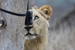
Modern nature conservation science operates at the frontier of technology. Innovative technology can enhance biodiversity conservation. Tags, sensors, camera traps, DNA sequencing, big data, new materials, high speed cameras, drones, facial recognition technology, bioacoustics, synthetic biology and AI are the new hand lenses and tweezers, enabling more effective biodiversity conservation.
WUR uses different innovative nature conservation techniques for better understanding nature, monitoring nature and take actions to conserve nature.
Making use of natural processes
WUR uses new technologies to develop biodiversity-friendly practices that work with natural processes rather than against them. Such building-with-nature concepts are employed in infrastructure development, such as artificial coral reefs.
Digital twins
Wageningen researchers use remote sensing and artificial intelligence to capture a digital reality ('a digital twin') of ecosystems or individual trees. Such 3D models can be used for calculations (e.g. the carbon content of a tree) and for understanding processes (e.g. the sand volume trapped by dune vegetation along the coast).
Smart techniques
An eDNA analysis uses traces of DNA in a water sample to obtain information about the prevalence and quantity of species. Virtual reality technologies can be used to reduce tourism pressure on protected areas. Real-time cameras can reduce nest disturbance by bird watchers. Synthetic biology technologies can produce nature or nature-based chemicals in the lab to replace harvesting from nature. High-speed cameras have revealed the flying behaviour of birds and insects which, for instance, helps us (together with Delft University of Technology) to construct better drones.
Monitoring nature
Monitoring is a basic technique to measure trends in the prevalence and movements of species, which is crucial for assessing the effectiveness of conservation. Camera traps, GPS, tags on animals, new sensors, facial recognition and bioacoustics all help us to better monitor nature. Such technologies, together with their real-time data streaming and advanced computer-based analytical tools, enable the early detection of threats to nature. A GIS keeps track of global deforestation, and advanced camera and sensor systems can trace illegal activities in protected areas.
Engaging citizens in nature conservation
New technologies offer a wide range of possibilities for engaging citizens in nature conservation and thus increasing public support for conservation. Camera traps, mobile phones, facial recognition tools, and interactive websites and apps have significantly enhanced citizen science for nature conservation.
Understanding nature
Publications
- 'Tracking down illegal timber', Wageningen World, June 2018
- A tiered approach for high-resolution characterization of the soil faunal community via dna metabarcoding
- Development of the benthic macrofauna community after tidal restoration at Rammegors : Progress report 1
- The ecology of Black Guillemot Cepphus grylle grylle chicks in the Baltic Sea region: insights into their diet, survival, nest predation and moment of fledging
- Estimating the spatial position of marine mammals based on digital camera recordings
- Drone brengt habitat jonge vis in uiterwaarden in kaart
- The impact of hunting on tropical mammal and bird populations
- The battle for the rhino (Wageningen World)
- Habitat Modification and Coastal Protection by Ecosystem-Engineering Reef-Building Bivalves (Book chapter, Nov 2018)
Presentation
Monitoring nature
Factsheets
Publications
- Tracking down Illegal timber
- Weather-dependent community shiftsin the aerobiome: measuring airborne dispersal of plants, mesofauna and microbes simultaneously via DNA metabarcoding
- Detecting Mammals in UAV Images: Best practices to address a substantially imbalanced dataset with deep learning
- Detecting animals in African Savanna with UAVs and the crowds
- Ontwikkelen van een remote Sensing monitoringssystematiek voor vegetatiestructuur
- Comparing RIEGL RiCOPTER UAV LiDAR Derived Canopy Height and DBH with Terrestrial LiDAR.
- The battle for the rhino
- Unfortunately, your cookie settings do not allow videos to be displayed. - check your settings
- Unfortunately, your cookie settings do not allow videos to be displayed. - check your settings
Engaging citizens in nature conservation
- Unfortunately, your cookie settings do not allow videos to be displayed. - check your settings
Publications
- Conservation 2.0: digital tools come to nature’s rescue
- Online and Offline Representations of Biocultural Diversity: A Political Ecology Perspective on Nature-Based Tourism and Indigenous Communities in the Brazilian Pantanal
- Digital technology and the conservation of nature
- Digital technology and human development: A charter for nature conservation
- Digital Conservation: An introduction
- Science as collective action


